 |
 |
 |
 |
 |
 |
 |
 |
 |
 |

  |
|
Home > Environmental Issues > Article > |
|||||
 |
|||||
Severe glacial reduction in southern AlaskaImages of retreating glaciers during more than 100 years in Glacier Bay National Park, provide striking evidence of how fast Earth is warming. Comparative photographs illustrate massive landscape, geomorphic, and floral changes. The big reduction in weight of ice on the Earth's crust is a cause of an increasing number of earthquakes - a new consideration in the complex effect of climate change. |
|||||
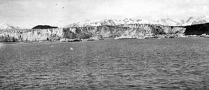
Muir and Riggs Glaciers 1941-2004 |
|||||
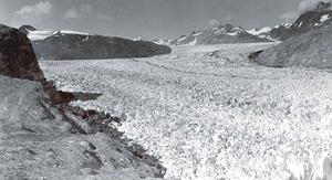
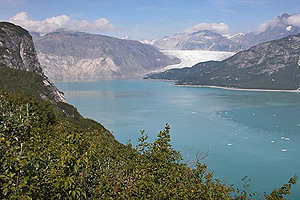
| The upper Muir Inlet in the east arm of Glacier Bay has been completely transformed in 60 years. In 1941 (upper) the ice was about 1000m (3000 feet) deep, and 3 km (1.8 miles) wide. Muir Glacier has retreated 20 km (12 miles) between 1941 and 2004 (lower), and 45 km (28 miles) since 1899. Riggs Glacier, which ran into Muir Glacier in 1941, has been severely reduced and terminates at Muir Inlet. Significant changes in vegetation accompanied the altered landscape, with immediate growth into the bare ground left by the retreating ice. Photos USGS |
||||
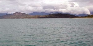
Carroll Glacier 1906-2004 |
|||||
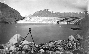
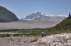
| Carroll Glacier in Queen Inlet in the west arm of Glacier Bay has thinned and stagnated since 1906. It has gone through the transition from a calving, tidewater glacier in open water in 1906 (upper), to a grounded, debris-covered glacier in 2004 (lower). Queen Inlet has been transformed from a 170 metre (560 feet) deep fiord (upper), to a glacial outwash plain that is well above sea level (lower). About 1.3 cu.km (0.3 cubic mile) of sediment has filled the upper section of the inlet. Since 1750, 2,500 cu.km (600 cubic miles) of ice has melted from Glacier Bay. Photos courtesy of USGS |
||||
Adams and Muir Glaciers 1899-2003 |
|||||
| In 1899 (upper) there was no vegetation on the shoreline of Glacier Bay near Muir Point on Muir Inlet. In 2003 (lower) vegetation is well established along the shoreline, and the Adams and Muir Glaciers have retreated. Climate change is also reflected in the treeless tundra north of Alaska's Brooks Range, where extensive vegetation growth, including, willows, alders, birch and many shrubs are thriving where permafrost previously kept the tundra frozen. The growth of shrubs on the tundra has increased by 40 percent in 60 years. Photo upper: USGS 1899
|
||||

Retreating glaciers spur Alaskan earthquakesNASA and USGS scientists have found that retreating glaciers in southern Alaska may be opening the way for future earthquakes. The study examined the likelihood of increased earthquake activity in southern Alaska as a result of rapidly melting glaciers. As glaciers melt they lighten the load on the Earth's crust. Tectonic plates, that are mobile pieces of the Earth's crust, can then move more freely. Historically, when big ice masses started to retreat, the number of earthquakes increased. More than 10,000 years ago, at the end of the great ice age, big earthquakes occurred in Scandinavia as the large glaciers began to melt. In Canada, many more moderate earthquakes occurred as ice sheets melted. Southern Alaskan glaciers are very sensitive to climate change, Sauber added. Many glaciers have shrunk or disappeared over the last 100 years. The trend, which appears to be accelerating, seems to be caused by higher temperatures and changes in precipitation. In southern Alaska, a tectonic plate under the Pacific Ocean is pushing into the coast, which creates very steep mountains. The high mountains and heavy precipitation are critical for glacier formation. The colliding plates create a great deal of pressure that builds up, and eventually is relieved by earthquakes. The weight of a large glacier on top of these active earthquake areas can help keep things stable. But, as the glaciers melt and their load on the plate lessens, there is a greater likelihood of an earthquake happening to relieve the large strain underneath. Even though shrinking glaciers make it easier for earthquakes to occur, the forcing together of tectonic plates is the main reason behind major earthquakes. The researchers believe that a 1979 earthquake in southern Alaska, called the St. Elias earthquake, was promoted by wasting glaciers in the area. The earthquake had a magnitude of 7.2 on the Richter scale. Along the fault zone, in the region of the St. Elias earthquake, pressure from the Pacific plate sliding under the continental plate had built up since 1899 when previous earthquakes occurred. Between 1899 and 1979, many glaciers near the fault zone thinned by hundreds of meters and some completely disappeared. |