 |
 |
 |
 |
 |
 |
 |
 |
 |
 |
|
|
  |

 |
Home > Environmental Issues > Article > |
 |
|||||||||||||||||||||||||||
|
|||||||||||||||||||||||||||
Asian tsunami damage prompts reconsideration in New ZealandInstitute of Geological and Nuclear Sciences Ltd
|
|||||||||||||||||||||||||||
 |
|||||||||||||||||||||||||||
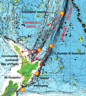
Possible earthquake and volcanic tsunami sources northeast of New Zealand | |||||||||||||||||||||||||||
|
"A magnitude 7 seabed earthquake could put a 10m-high tsunami wave ashore along numerous stretches of the New Zealand coast. Such a tsunami might take only minutes to reach the coast." A locally produced New Zealand tsunami might not even require an earthquake. A large underwater landslip or volcanic eruption would be enough to trigger a tsunami. Dr Cowan and six other New Zealand scientists, engineers, and emergency managers spent a week inspecting the damage on Thailand's Andaman (Phuket) coast. | |||||||||||||||||||||||||||
New Zealand has not experienced a natural disaster of the scale
of the 2004 Indian Ocean tsunami since European settlement, but could easily do so in the
future.
|
|
|
| A trigger in New Zealand could be a moderate (magnitude 6.5 or greater) earthquake within 200km of the coast. This type of offshore quake can occur as often as once a year. A tsunami of comparable volume and momentum striking a populated New Zealand coastal area could easily overwhelm civil defence response and recovery arrangements. A tsunami is not a single breaking wave. It is a raging torrent or wall of water that surges inland. The backwash from a retreating tsunami can produce as much damage as the forward surge. When a backwash meets a subsequent incoming surge, hugely destructive vortexes of water can form. They can be hundreds of metres across.[End Institute of Geological and Nuclear Sciences text]
|
|
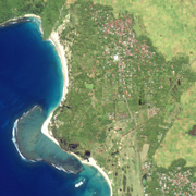
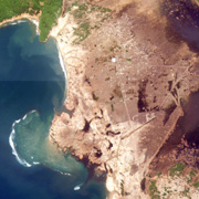
The 2004 Sumatra-Andaman 9.1 magnitude undersea earthquake generated a tsunami that caused one of the deadliest disasters in modern history. More than 300,000 people died, an unknown number are missing, and 2 million were left homeless. Indonesia's Aceh region on the northern tip of the island of Sumatra was one of the hardest hit. Before and after satellite images (left) show the complete devastation of the town of Lhoknga, with the land stripped of vegetation and buildings.
|
| The Sumatra-Andaman earthquake occurred three days after a magnitude 8.1 earthquake in the subantarctic ocean east of the New Zealand Auckland Islands and north of Australia's Macquarie Island. Some seismologists speculate that the first event may have been a catalyst for the Sumatran earthquake, because the two locations are on opposite sides of the Indo-Australian Plate.
|
|
| Living on the edge, on the Ring of FireNew Zealanders are accustomed to earthquakes and volcanic eruptions. GNS records 14,000 earthquakes a year. Most are small, but 200 are big enough to be felt nearby, one magnitude 6 or greater occurs each year, there is one magnitude 7 every 10 years, and a magnitude 8 every 100 years. With the exception of the most severe shocks, earthquakes are a form of amusement and complacent embracement of living in the "Shaky Isles". Only a handful of New Zealanders living today have experienced or been affected by an earthquake greater than 7 magnitude. The major earthquakes of 1855 in Wellington (8.0 magnitude), and 1931 in Napier (7.9) which was New Zealand's worst natural disaster, and the Tarawera eruption of 1886, no longer cause thought for fear or caution. Few Aucklanders think twice about the possibility of a volcano erupting beneath them, despite the potentially active volcanic field containing 63 former eruption locations throughout the city. One of these is the Waitemata Harbour landmark, Rangitoto Island, which is a new island that rose from beneath the sea from a volcanic eruption 600 years ago. Many New Zealand cities and towns have unknowingly originated in earthquake prone locations, and knowingly developed (with Wellington, Nelson, Hastings and Masterton rebuilt) despite the risk of further events. In modern times the country has invested in enforcement of strong earthquake design standards for buildings, so that continued expansion is somewhat justified. The Hawkes Bay earthquake of 1931 caused the examination of building standards which were found to be most inadequate. The same consideration has not been given to tsunami design standards following the review of damage from the Indian Ocean disaster. Many people live with the few precautionary measures available for volcanic eruptions, limited to seismic monitoring to predict an event, which is not always possible. The hotspots are numerous - the city of Rotorua is surrounded by five volcanoes, in the middle of the Taupo Volcanic Zone stretching 250km, which marks the boundary between the Australian and Pacific tectonic plates. Taupo is next to the sunken caldera vent in Lake Taupo that erupted 20 cub.km of airfall tephra over 30,000 sq.km, and a pyroclastic flow of 30 cub.km over 20,000 sq.km.; Kawerau and its paper mill are next to the Mt Edgecombe volcano; and New Plymouth sits on top of the lava flows from Mt Taranaki. The potential occurrence of a tsnumani disaster on a North Island east coast community is far greater than a community built next to an active volcano. The risk is multiplied by the number of potential eruption or earthquake locations along the Kermadec Trench and Ridge. The shocking images of the Sumatra-Andaman tsunami disaster have not affected the desire of New Zealanders to live in a bach at the beach. A change in the traditional attitude towards volcanoes is needed, to respect the destructive power of a tsunami on an entire coastline. | ||||||||||||||||

|
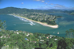
Coastline in the crosshairs of a tsunami .....The Coromandel resort township of Pauanui (above) is one of many low-lying ocean beach communities along the east coast of the North Island, that are right in the path of a potential tsunami. It is built on a large sand dune which forms a harbour.
Photo permission of Virtual New Zealand A tsunami could originate from a landslide of the seabed, an earthquake in the subduction zone of the Kermadec Arc, or a volcanic eruption on the ridge above the trench from numerous locations, some less than 200km off the Northland, Auckland, Coromandel and Bay of Plenty coast.
The east coast is New Zealand's most popular summer playground, with the highest concentration of beach resort, second-home and retirement communities. Stretched along 250km of Bay of Plenty/Coromandel coast, Ohope, Papamoa, Omanu, Mount Maunganui, Waihi, Whangamata, Opoutere, Pauanui and Whitianga are all low-lying beachfront communities accutely vulnerable to a Kermadec generated tsunami. Countless beach subdivisions have occurred at locations along the coast outside the communities. On the roughly 100km of Coromandel Peninsula east coast, Waikawau Bay is the only beach that is not occupied by dwellings.
Possible tsnunami damage has not deterred a throng of buyers from making million dollar property investments in even the smallest east coast communities. Real estate brokers reported in April 2005 that the cost of coastal property has almost doubled in two years. A Bay of Plenty Times survey of seaside property from Waihi to Ohope found prices over $1 million to be normal. Unimproved lots of 800 sq.m at Waihi Beach are valued at $1.1 million. Tsnunami planning considerations have no priority as the Thames Coromandel District put out tenders for construction of sewage treatment plants at Tairua/Pauanui, Whitianga and Whangamata. A development ban of the last five years on some of the hottest Coromandel real estate is expected to be lifted at the end of 2006, to coincide with completion of the plants, which in the case of Tairua/Pauanui alone, will allow development of 5,400 new homes. Development of areas vulnerable to a tsunami disaster .....Mount Maunganui is the most developed east coast resort community, built on a narrow sand isthmus connecting the mainland with the small volcanic peak of Mount Maunganui. A large tsunami will wash right over the low isthmus, over the Port of Tauranga on its inland side, and crash into the city across the harbour.The powerful force of the incoming surge of a large tsunami could sweep structures built on sand off their foundations, and the retreating wave could suck the land beneath them out to sea. The shoreline of some locations could dramatically change, with land that is low lying sand dune being washed away.
The science of computer modelling that simulates a tsunami has made rapid advances. Within hours of the March 2005 8.7 earthquake west of Sumatra, Dr William Powers of Geological and Nuclear Sciences was able to accurately estimate that a group of islands off Indonesia's coast was hit by a 2.5-3.0m tsunami. Previous estimates of tsunami hazard in New Zealand, where based only on inundation, are likely to underestimate the risk as they do not account for momentum of the flows. With the shape of the seafloor defined by mapping, the size of a tsunami wave can be predicted for various volcanic or earthquake conditions. With the height determined, an assessment of protection from islands and coastal promontories, and consideraton of momentum, the extent of tsunami impact over land can be defined by the topography. |
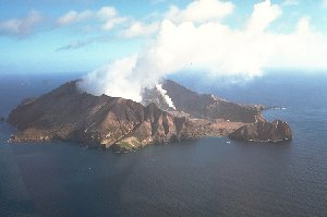
Gas and steam rising from the White Island crater, New Zealand's most active and continually
changing volcano, 48km off the Bay of Plenty coast. |
|
|
"The generation of some historic tsunami by relatively small eruptions at other volcanoes suggests that some risk of tsunami damage over restricted sections of the Bay of Plenty coast from major White Island eruptions cannot be completely excluded." (Cole, Nairn and Houghton) The definition of tsunami impact zones on land should be utilized in the determination of government land use policies. The process is similar to land use zoning that prevents development from occuring in flood plains. New land development should not occur in a tsunami impact zone. If development is allowed, building codes relating to tsunami resistent foundation design and building elevation above sea level should be put in place. Property buyers must be advised at the time of purchase if the land is in the path of a tsunami. More importantly, it is necessary to identify tsunami prone areas, so that emergency warning systems can be implemented within them. There also needs to be a greater awareness that a close earthquake or eruption, will cause a tsunami moving at up to 800kmh to land on the coast within a few minutes. So much more is now known about the powerful force of a tsunami. Its destructive power can cause massive destruction throughout an entire region. Existing coastal development is a heavy burden on the nation, in the potential loss of lives, homes, industry and infrastructure. National and local governments must act. Even with precautionary measures in place and restrictions on new coastal development, the cost of tsunami damage to the nation will be overwhelming. |
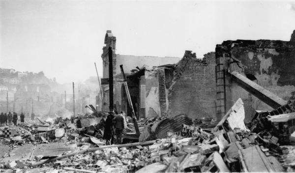
Central Napier after the 1931 earthquake. |
|

 See map of larger area
 View larger image